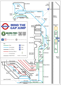

What started out as a bit of fun – sketching the Majura Pines trails in the style of Harry Beck’s iconic London Underground transport map – became one of our most popular social media posts. Many people requested that we create a version as a full directional trail map. Whilst, obviously, not geographically accurate it is easy to see the appeal schematic diagrams to simplify complicated systems and there are not many places more complicated than the southern end of Majura Pines. None of the Majura Pines trails are particularly long so you are only really navigating to the next junction, which this map shows.
Click on the button below to download a printable PDF of the Majura tube map.
Obviously our traditional map is still available and will be maintained. We also highly recommend that you download the free phone app Trailforks, which we also keep up to date.
Now to start work on the other request; tube map related merch…